If You Ask Me: What does SVD mean?
by Anthony A. R. Gunn, CBE
Tuesday, September 7, 2004
This is the question that I asked of my late father. If anyone would know, surely he would. This trivia question has also run through the minds of millions of people over the past decades as they head to or ship items to St. Vincent & the Grenadines.
I too often wondered why 'SVD' was the airport destination code for Arnos Vale airport (now the E.T Joshua Airport), especially since 'SVG' had become the popular country code for St. Vincent & the Grenadines since the early 1980's. I only really thought of it whenever I saw it and then immediately forgot to
look into it any further; and so time went on. Finally, about 10 yrs ago, I remembered to ask
"St. Vincent, Diamond" was my father's reply. Of course! Duh! Everybody knows that Diamond, on the Southeast Coast, was the location of SVG's first airport, hence SVD. Er, well, actually, no, not everybody. In fact, very, very few people know or remember this pertinent fact.
Yes, my father had told me about the Diamond airport, years and years ago, even took me to see for myself. He pointed out that planes invariably landed from the sea, yes, downwind (yikes!) touched down on the grassy runway just inside of the beach and sand dunes, and ran up along the valley, crossing over a
man-made wooden bridge that spanned the river running down to the sea, and came to a stop in front of the terminal building dispersing its extremely gracious and lucky passengers.
Departing passengers would then board the plane, which taxied out from the airport terminal building, which is still there in among the trees at Diamond (near the gate to the unused dairy, behind the trees to the left take the family or friends and go and have a look one day), rev up, scoot over the bridge,
rumble down the grassy runway to the east, heading literally down the slope of the valley to the sea, and then lift into the trade winds and fly away, usually to Barbados.
This went on from the first flights to St. Vincent of the new-fangled invention called the airplane, sometime around World War I through World War II, for about 20 to 25 years.
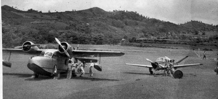
Then, like today, debates and arguments lingered as to whether or not this was the best place for "the airport", and in the very early 1950's, the decision was made to "move" the airport, and indeed the entire air transport system, over to Villa and to use sea-planes; the Grumman Goose being the popular
airplane at the time.
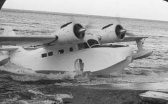
So, now we landed and took off from the water in front of Villa Beach in the Young Island Channel. Diamond was abandoned, and a ramp was built to accommodate the sea-plane right where the taxis park today on the St Vincent side of the "Young Island Dock". This was the new SVD airport. The reef joining what is now "Mariners' Inn-to-Calliaqua Bay Point" over to Young Island was blasted open to accommodate the flights (can you imaging doing that today?), creating a channel and current flow that effectively eroded
all of Calliaqua's beach, and most of the beach at Villa, especially up at the Eastern end; an ecological disaster that even after 50 years of installing 'sand-groins' have not helped; we have to seriously look into building this reef back. Even I remember a large beach with numerous coconut trees running from
"Mr. Cato's home" in the corner all the way past what is now the Iguana into and around the Calliaqua bay; now the water slams into the properties, the entire beach having been washed away.
The seaplanes landed from the Indian Bay area and came into the 'airport',
then took off after taxiing out to the Indian Bay area and took off in between
Young Island and Villa Beach, heading out into Calliaqua Bay, then off to
Seawell in Barbados.
One day my Grandmother was standing at the very end of the Aquatic Club jetty, presumably either waving someone off or just looking at a departing seaplane one day, when something went very wrong, and the plane careened out of control, heading straight for her and a certain crash. Fortunately, the pilot gained control and headed the plane towards a clear area but had to effectively crash land the plane anyway. I gather everyone was okay and the plane was pulled up onto the beach where Fantasea Tours is now, just to the west of the Aquatic Club.
So, once again, debate reigned about what to do with our "airport". Arnos Vale was a cane field for most of its lower section towards the beach, running up and over Cane Garden (hence its name). The "main road" from Kingstown to the Windward side of the island, dissected the Arnos Vale valley about midway. To the north of the road, as it crossed the valley floor, was the
horse racing track/garrison. The what?! Yes, horse racing track!
There is no horse racing in SVG today, presumably a casualty of the airport being built there, although I can only assume that if there was a big demand for such, a new track would have been built by now. I do not know who said what, who influenced whom and what engineering went into it, but the decision was made to build an airport in Arnos Vale. Imagine the confusion and opposition to such a move. I am sure that there was a lot of debate and opposition to such development. "Where will we grow our sugar?"
"What about the horses; the noise will scare them" are, I am sure, just the tip of that iceberg.
The capital of SVG was once firmly settled into Georgetown; the perfect place; why move it? Then it was moved to Calliaqua. Heavens above; imagine the nattering back then. Then it was moved to Kingstown among much gnashing of teeth and flailing of hands; what are they doing to our island?! Years later, some Barbadians vehemently opposed the building of the 'ABC Highway'. "Waste of money", "It will use up sugar land" etc etc. Uh huh; can you imagine Barbados today without the ABC Highway? Parisians fought hard against the idea of erecting that ugly monster, the Eiffel Tower; who wants that in their backyard? Decades before all of this, man could not even fly and those who thought that they could were all but committed to the "Red Roof House" (Remember the firmly believed 'fact' that the Earth was "flat"?)
Meanwhile, over in SVG, the new SVD airport took shape and was opened as the Vigie Airport in Arnos Vale in the early 1960's; and yes, the "highway" ran right across the runway.
When a plane was about to land or take off, the control tower operator would sound a horn, turn on a pair of 100 watt red spot lights that shone towards the road, and two 'barrier operators', dressed in khaki uniforms, would trundle across the road with a horizontal bamboo pole, waving traffic to a stop. Cars would then await the second horn-blow and the extinguishing of the red
lights which would indicate the all-clear to the barrier-men, who then walked the bamboo poles back across the road, allowing cars to proceed across the runway, and on their way.
Villa then developed to eventually become the main tourism and entertainment
strip it is today.
Today, SVG and Dominica are the only "countries" in the Eastern Caribbean without International Airports. So, once again, debate reigns about what to do with our "airport". Some say "this is just fine" and "we good right so". Some say no, we need an international airport as we are uncompetitive and cannot grow without one. Hmmm Similarly, there is a fascinating national debate that is presently underway,
that has Vincentians around the planet discussing the pros and cons of whether or not to build a "cross country highway".
Some say 'no way'; it will affect the environment, use up scarce financial resources, open up the forests to man's building and other exploits and intrusion onto the watershed areas; plus no one ever wants to or needs to drive directly from the Upper Windward side to the Upper Leeward side. Others say that we should 'use the money' to build the international airport first, then consider The Road. The Road will cost fifteen to twenty million dollars; The Airport hundreds of millions, no comparison.
Still others say build them both; they are both critical to growth and development! They argue that the major expense of The Airport will be satisfactorily offset by the "inherent value" in developing the immense space that will become available for major development of a new city, when the runway is cleared
from Arnos Vale; true!
Recently, SVG's failure to secure mainstream Cricket World Cup 2007 games set tongues wagging. Yes, SVG will get some warm-up games, and yes, the place wil l be full of fans irregardless, but a lack of "accommodation" and "International Airport" are being touted as the "main reasons" for this. As someone also intimately involved with the tourism industry, kindly allow me to offer this: "Accommodation" is not "the problem", "airlift" is the fundamental problem Hoteliers in SVG will happily build 'endlessly' more rooms if the airlift capacity was there; i.e. an International Airport. Hotel rooms can be added on "overnight"; lots and lots within a year or two. An International Airport would take several years to build; therein lies the
problem, notwithstanding the absolute cost and financing issues of the airport, which would have to be built by moving an enormous amount of land and earth, mountains and valleys Question: Which first? Chicken or egg? Airport or Hotels? Answer: Airport first! - Hotels, chickens and eggs will follow! So, will SVD ever become an International Airport? Are recent announcements by the Government that Diamond/Argyle International Airport is perhaps in our collective, near future mean that the airport is moving back to the South East Coast, from whence it came?
Is Arnos Vale the future capital of St. Vincent & the Grenadines? Will we ever drive directly across the north of the island, without barriers, bamboo or otherwise?
Whew! Decisions! Decisions! Never say "Never"! Attitude is everything!